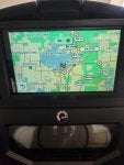
Recently purchased a garmin drivesmart 65 for my backcountry, it has VV trail maps for midwest, i was wondering if there was any way to overlay aerial views on the device?
Recently purchased a garmin drivesmart 65 for my backcountry, it has VV trail maps for midwest, i was wondering if there was any way to overlay aerial views on the device?
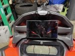
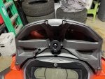
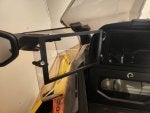
don't mind the two additional holes, measure twice cut once. unit and mount came from D3 Customs out of Grand Rapids. haven't tested it out yet, if i like it i may buy the tread to get aerial mapping, as i have not figured out how to place them on this unit.
Have you had a chance to use it yet? I was thinking about getting one of the Drivesmarts and replace my cel phone holder. Do you know how well they handle the cold/moisture?
They don't like to get wet!!! I ran one this year but I forgot to seal the openings with flowable silicone ( I even bought some for this unit)
It did run good all year. Once I got the settings sorted out with screen brightness etc. Cold weather didn't seem to bother it.
The new heated cell holders are awesome for these. Had horrible troubles keeping mine working in the cold till I inserted in this holder. Small mods needed to make it work this well.
I ended up getting one, and after mine was out in it's first -25 day, regardless of being plugged in, the battery was destroyed to the point where it could barely keep itself on. Became mostly un-usable.
Related Threads
?
?
?
?
?
?
?
?
?
?
?
?
?
?
?
?
?
?
?
?
Ski-Doo Snowmobiles Forum
posts
8M
members
175K
Since
2002
A forum community dedicated to Ski-doo snowmobile owners and enthusiasts. Come join the discussion about trails, racing, performance, modifications, classifieds, troubleshooting, maintenance, and more!